


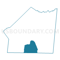
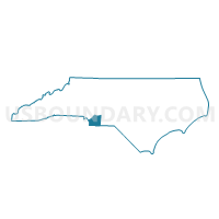
Voting District 024, Union County, North Carolina
About
Outline

Summary
| Unique Area Identifier | 641537 |
| Name | Voting District 024 |
| County | Union County |
| State | North Carolina |
| Area (square miles) | 42.11 |
| Land Area (square miles) | 41.71 |
| Water Area (square miles) | 0.40 |
| % of Land Area | 99.05 |
| % of Water Area | 0.95 |
| Latitude of the Internal Point | 34.86319400 |
| Longtitude of the Internal Point | -80.54280090 |
Maps

Graphs
Select a template below for downloading or customizing gragh for Voting District 024, Union County, North Carolina


Neighbors
Neighoring Voting District (by Name) Neighboring Voting District on the Map
- Voting District 007, Union County, NC
- Voting District 021, Union County, NC
- Voting District 023, Union County, NC
- Voting District 025, Union County, NC
- Voting District 026, Union County, NC
- Dudley-Mangum Voting District, Chesterfield County, SC
- Spring Hill Voting District, Lancaster County, SC
Top 10 Neighboring County Subdivision (by Population) Neighboring County Subdivision on the Map
- Buford township, Union County, NC (10,323)
- Pageland CCD, Chesterfield County, SC (9,755)
- Tradesville CCD, Lancaster County, SC (3,818)
Top 10 Neighboring Unified School District (by Population) Neighboring Unified School District on the Map
- Union County Public Schools, NC (201,292)
- Lancaster County School District, SC (76,652)
- Chesterfield County School District, SC (46,734)
Top 10 Neighboring State Legislative District Lower Chamber (by Population) Neighboring State Legislative District Lower Chamber on the Map
- State House District 68, NC (140,076)
- State House District 69, NC (77,122)
- State House District 44, SC (34,343)
- State House District 65, SC (33,735)
Top 10 Neighboring State Legislative District Upper Chamber (by Population) Neighboring State Legislative District Upper Chamber on the Map
- State Senate District 35, NC (249,030)
- State Senate District 16, SC (121,820)
- State Senate District 27, SC (91,873)
Top 10 Neighboring 111th Congressional District (by Population) Neighboring 111th Congressional District on the Map
- Congressional District 9, NC (852,377)
- Congressional District 5, SC (767,773)
- Congressional District 8, NC (709,449)
Top 10 Neighboring Census Tract (by Population) Neighboring Census Tract on the Map
- Census Tract 209.02, Union County, NC (5,929)
- Census Tract 9501.01, Chesterfield County, SC (5,397)
- Census Tract 209.01, Union County, NC (5,124)
- Census Tract 206.02, Union County, NC (4,688)
- Census Tract 205.02, Union County, NC (3,912)
- Census Tract 101, Lancaster County, SC (3,818)